


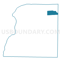
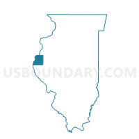
LAHARPE II Voting District, Hancock County, Illinois
About
Outline

Summary
| Unique Area Identifier | 571089 |
| Name | LAHARPE II Voting District |
| County | Hancock County |
| State | Illinois |
| Area (square miles) | 12.70 |
| Land Area (square miles) | 12.70 |
| Water Area (square miles) | 0.00 |
| % of Land Area | 100.00 |
| % of Water Area | 0.00 |
| Latitude of the Internal Point | 40.56453370 |
| Longtitude of the Internal Point | -90.97026160 |
Maps

Graphs
Select a template below for downloading or customizing gragh for LAHARPE II Voting District, Hancock County, Illinois


Neighbors
Neighoring Voting District (by Name) Neighboring Voting District on the Map
- BLANDINSVILLE Voting District, McDonough County, IL
- DURHAM Voting District, Hancock County, IL
- FOUNTAIN GREEN Voting District, Hancock County, IL
- HIRE Voting District, McDonough County, IL
- LAHARPE I Voting District, Hancock County, IL
- PILOT GROVE Voting District, Hancock County, IL
Top 10 Neighboring County Subdivision (by Population) Neighboring County Subdivision on the Map
- La Harpe township, Hancock County, IL (1,473)
- Blandinsville township, McDonough County, IL (846)
- Fountain Green township, Hancock County, IL (288)
- Pilot Grove township, Hancock County, IL (280)
- Durham township, Hancock County, IL (278)
- Hire township, McDonough County, IL (229)